Professional AEC Drone Services in Columbus, Ohio
Professional
Drone Services
Aerial Photography · Drone Mapping & 3D Modeling · Virtual Tours · Videography · Thermal Imaging · LiDAR
ARO Aerial Inc. provides professional drone services for organizations that need accurate, repeatable, and defensible aerial data. The company serves construction teams, architecture and design firms, engineering consultancies, developers, and property owners across Columbus and Central Ohio, delivering calibrated imagery, georeferenced spatial data, and immersive visual experiences tailored to the client's industry, project, and workflow.
ARO Aerial operates at the intersection of aerial technology and professional-grade documentation. Every mission is planned, executed, and delivered with the precision, methodology, and technical depth that AEC clients require.
FAA Part 107
MBE Certified
EDGE Certified
OSHA 10 Trained
L1 Thermographer
What We Do
We operate at the intersection of aerial technology and professional-grade documentation. Every mission is planned, executed, and delivered with the precision, methodology, and technical depth that our clients' projects demand.

Aerial Photography
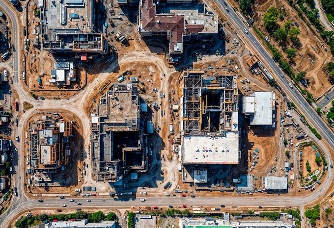
High-resolution, geo-tagged aerial imagery for site documentation, condition assessment, progress tracking, and marketing. Calibrated, repeatable, and production-ready.
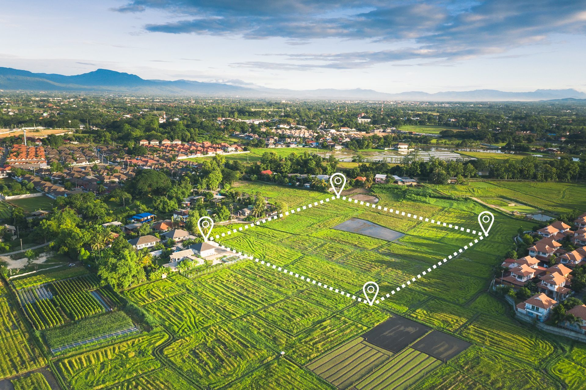
Drone Mapping & 3D Modeling
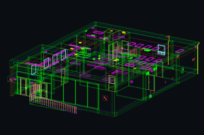
Georeferenced orthomosaic maps, digital elevation models, volumetric calculations, and photogrammetric 3D reconstructions. GCP-aligned, survey-grade accuracy.
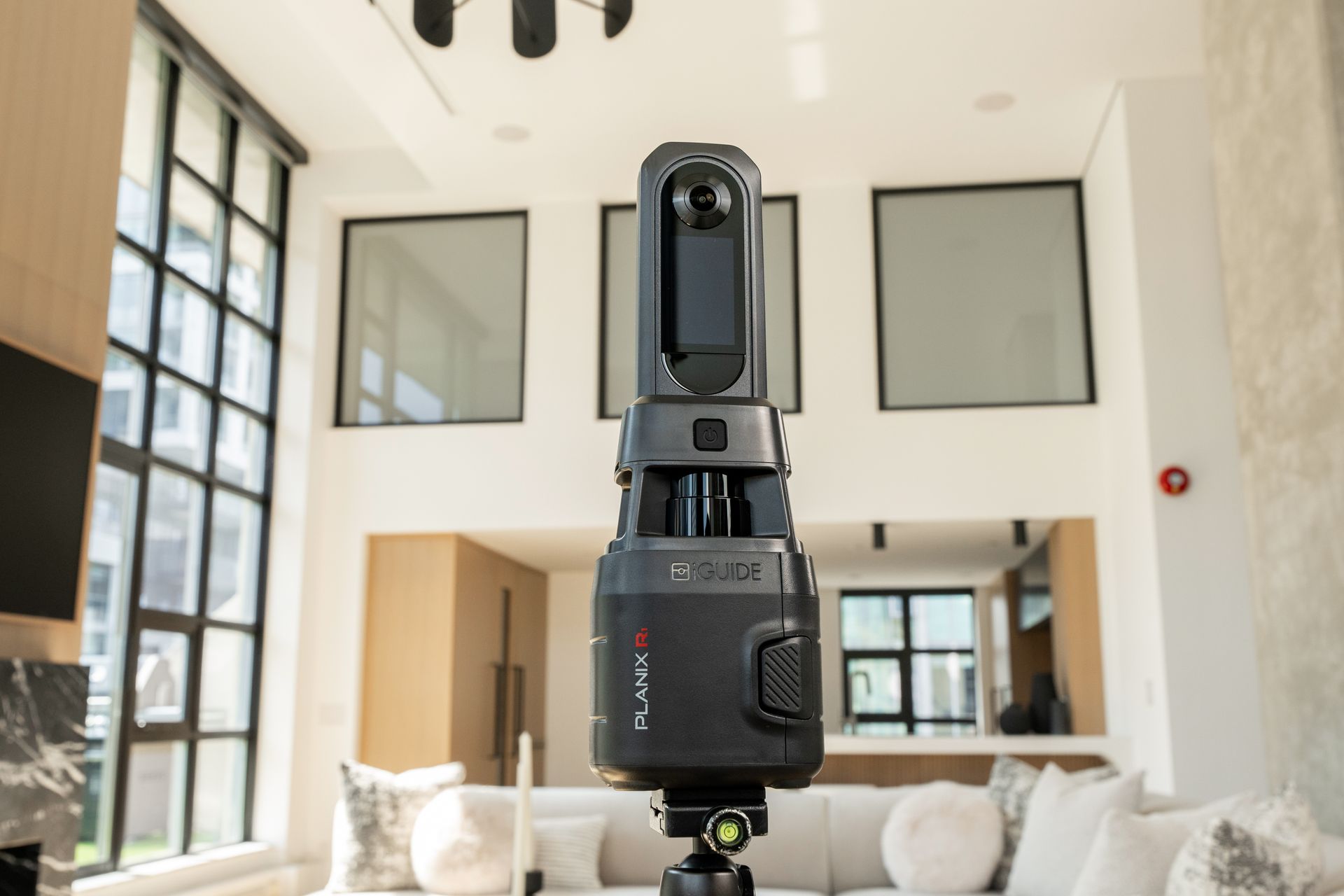
Virtual Tours & 360° Walkthroughs
Interactive, navigable, measurement-ready digital experiences. Aerial + interior combined tours with iGUIDE floor plans and cloud-based access.
Videography
Cinematic-quality aerial video for documentation, stakeholder communication, milestone storytelling, and marketing. Full post-production pipeline.
Thermal Imaging & Infrared Inspection
Radiometric thermal detection and quantitative reporting. Building envelope assessment, electrical thermography, moisture detection, and energy performance analysis. Level 1 sUAS Thermography certified.

LiDAR
Dense, classified point cloud data with vegetation penetration and survey-grade accuracy. Digital elevation models, corridor mapping, and scan-to-BIM ready deliverables.
Industries We Serve
Our drone capabilities serve organizations across multiple industries — each with unique requirements for accuracy, deliverables, and integration. We tailor our methodology, reporting, and outputs to match your industry's standards and your team's workflow.
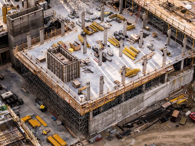
General contractors, construction managers, civil contractors, and developers; progress documentation, earthwork verification, safety imaging, and as-built records across the construction lifecycle; deliverables integrate with Procore, PlanGrid, Bluebeam, and BIM platforms.
Architecture & Design
Architects, landscape architects, interior designers, and planning firms; existing conditions documentation, site context imagery, BIM-ready spatial data, measurement-ready virtual tours, and portfolio photography across every phase of the design process.
Engineering
Civil, structural, MEP, and environmental engineers; survey-grade topographic data, classified point clouds, volumetric calculations, corridor mapping, and quantitative thermal inspection formatted for Civil 3D, ArcGIS, and engineering analysis platforms.
We also serve real estate, municipal government, energy, and commercial property management clients. Contact us to discuss your project.
Credentials, Certifications & Compliance
ARO Aerial operates to professional standards across every mission. Our certifications, insurance, methodology, and experience are the foundation of every deliverable we produce — and the reason organizations across construction, architecture, and engineering trust us with their most critical projects.
Certifications & Licensing
- FAA Part 107 Remote Pilot Certificate — licensed for all commercial drone operations
- Level 1 sUAS Thermography Certification — qualified for quantitative infrared inspection with calibrated radiometric sensors
- OSHA-aware safety protocols — compliant with jobsite and facility safety requirements
- All operations conducted under current FAA regulations, airspace authorizations, and LAANC compliance
Insurance & Risk Coverage
- Commercial general liability insurance
- Drone-specific aviation liability coverage
- Additional insured endorsements available for project-specific requirements
- Certificate of Insurance (COI) provided for every engagement
Accuracy & Methodology
- GCP-aligned (Ground Control Point) methodology achieves sub-inch horizontal and vertical accuracy on mapping and LiDAR deliverables.
- Documented, repeatable capture and processing workflows produce defensible data suitable for design coordination, contract administration, and dispute documentation.
- Sensors are calibrated with verified accuracy specifications. Quality assurance verification is performed on every deliverable before release.
- Thermographic inspection methodology is aligned with ASTM standards.
- All flight operations are conducted under current FAA regulations, with airspace authorizations and LAANC compliance where required.
Experience & Track Record
- 6+ years of professional commercial drone operations
- Thousands of missions across construction, architecture, engineering, real estate, and municipal projects
- Trusted by general contractors, architecture firms, engineering consultancies, developers, and property owners across Ohio
- Experience with projects ranging from single-site captures to multi-phase, multi-year documentation programs
Platform Integration & Deliverable Standards
- Deliverables formatted for direct integration — no additional conversion required
- Construction platforms: Procore, PlanGrid, Bluebeam, DroneDeploy
- Design platforms: Revit, SketchUp, Rhino, AutoCAD, ArchiCAD
- Engineering platforms: Civil 3D, ArcGIS, QGIS, Global Mapper, Navisworks
- Virtual tour platforms: iGUIDE, DroneDeploy
- Standard export formats: GeoTIFF, LAS, LAZ, E57, RCP, LandXML, DXF, OBJ, PDF, JPEG
Communication & Project Coordination
- We speak your industry's language — whether you're a GC, a project architect, or a PE
- Direct communication with the pilot and project lead — no call centers or account managers
- Clear scoping, transparent pricing, and defined deliverable timelines
- Post-delivery support for questions, re-exports, and platform integration
Procurement-Ready: MBE & EDGE Certified
ARO Aerial Inc. is certified under the State of Ohio's Minority Business Enterprise (MBE) and Encouraging Diversity, Growth and Equity (EDGE) programs, administered by the Ohio Department of Development. These certifications qualify ARO Aerial for inclusion in diversity procurement programs and public-sector contracting requirements across Ohio.
What This Means for Your Clients
- ARO Aerial is an eligible vendor for state, county, and municipal contracts with MBE/EDGE participation requirements.
- ARO Aerial qualifies as a certified diverse subcontractor for general contractors, construction managers, and prime consultants meeting diversity spend goals.
- EDGE certification covers construction, architecture and engineering, professional services, goods and services, and information technology — aligning with ARO Aerial's service verticals.
- Certification status can be verified through the Ohio Department of Development's certified business directory.
- Certificate documentation is available upon request for bid submissions and prequalification packages.
- SAM.gov registration enables federal and federally-funded contract participation; UEI is provided upon request.
Why the Certifications Matters
- Public agencies and large private owners increasingly require MBE/EDGE participation on funded projects.
- Prime contractors and A/E firms can count ARO Aerial toward diversity subcontracting goals.
- Procurement friction is reduced — certification is in place, documentation is ready, and COI is available for every engagement.
- ARO Aerial brings both the certification and the technical capability — clients do not trade quality for compliance.
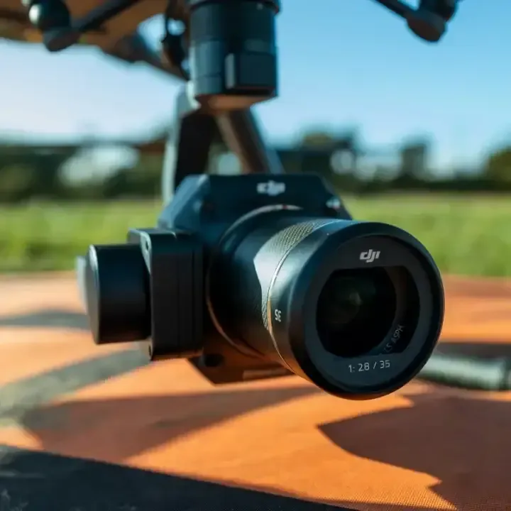
We operate premium-tier drone platforms and professional-grade sensors — not consumer equipment. Our hardware is selected for the accuracy, reliability, and output quality that construction, architecture, and engineering professionals require. Every platform is maintained, calibrated, and deployed with documented methodology.
Aircraft & Sensor Platforms
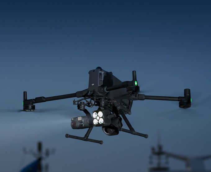
- DJI Matrice 350 RTK (M350) with Zenmuse P1 — Full-frame 45MP photogrammetry camera with RTK positioning; primary platform for high-resolution aerial photography, orthomosaic mapping, and 3D modeling; delivers sub-centimeter GSD at standard mapping altitudes.
- DJI Matrice 4 Series (M400) with Zenmuse L3 — Next-generation LiDAR sensor with integrated RGB camera. Multi-return laser scanning for dense point cloud capture, vegetation penetration, and bare-earth terrain modeling. Survey-grade accuracy with real-time quality monitoring.
- DJI Mavic 4 — Compact, professional-grade platform for rapid-deployment photography, videography, and site documentation. Premium optics and stabilization in a portable form factor for tight sites and fast-turnaround captures.
Sensors & Capture Systems
- Calibrated radiometric thermal sensors for quantitative infrared inspection
- 360° capture systems including iGUIDE for measurement-ready virtual tours and floor plans
- Multi-return LiDAR with GPS/INS integration for classified point cloud generation
- 4K+ video with stabilized gimbals for cinematic-quality aerial videography
Processing & Software Ecosystem
- Pix4D, DroneDeploy, Agisoft Metashape — photogrammetry and orthomosaic processing
- Global Mapper, LP360 — LiDAR classification and surface generation
- Platform integration: Procore, PlanGrid, Bluebeam, Civil 3D, Revit, ArcGIS, QGIS, Navisworks
- Standard export formats: GeoTIFF, LAS, LAZ, E57, RCP, LandXML, DXF, OBJ, PDF, JPEG
Process
How It Works
Project Scoping
Engagement begins with requirements gathering: area of interest, accuracy standards, deliverable formats, integration platforms, and schedule. Both one-time captures and recurring documentation programs are scoped.
Professional Capture
An FAA Part 107 certified pilot executes the mission using the appropriate sensor, flight plan, and methodology for the project. Every capture is systematic, safety-first, and documented.
Processing & Delivery
Clients receive production-ready deliverables processed, formatted, and organized for their platform and workflow. Cloud-based access keeps the entire project team connected.
Post-Delivery Support
Re-exports, format conversions, platform-integration assistance, and follow-up questions are supported after delivery.
Service Area
Columbus & Central Ohio
We provide professional drone services for projects in:
- Gahanna
- Delware
- New Albany
- Westerville
- Grove City
- Dublin
- Hillard
- And all surrounding Central Ohio markets
Frequently Asked Questions
What drone services does ARO Aerial provide?
ARO Aerial provides aerial photography, drone mapping and 3D modeling, virtual tours and 360° walkthroughs, videography, thermal imaging and infrared inspection, and LiDAR scanning. All services are available as one-time captures or recurring documentation programs.
What industries does ARO Aerial serve?
Construction, architecture and design, engineering, real estate, municipal government, energy, and commercial property management. Each industry receives tailored methodology, deliverables, and reporting aligned to its standards and workflows.
How accurate are ARO Aerial's drone services?
With ground control points and professional-grade sensors, mapping and LiDAR services achieve sub-inch horizontal and vertical accuracy — comparable to traditional survey methods but delivered faster and with broader coverage.
What areas does ARO Aerial cover?
Columbus and all of Central Ohio, including New Albany, Dublin, Westerville, Grove City, Hilliard, Delaware, Marysville, Lancaster, Newark, and surrounding markets. Statewide and regional engagements are available.
How do I get started with ARO Aerial?
Contact ARO Aerial to discuss the project. The team will scope requirements, recommend the right service and methodology, and deliver a proposal aligned to the timeline, budget, and deliverable needs.
Is ARO Aerial a licensed land surveyor or professional engineer?
No. ARO Aerial offers technology-driven services for collecting aerial data. ARO Aerial is not a state-licensed land surveying or professional engineering firm, and its staff are not licensed professional engineers or surveyors. Its work supplements, but does not replace, licensed PE or PLS services.
Is ARO Aerial certified for public-sector work?
Yes. ARO Aerial holds MBE and EDGE certifications from the State of Ohio, is registered on SAM.gov, and is an eligible vendor for state, county, municipal, and federally-funded contracts with diversity participation requirements.
What insurance does ARO Aerial carry?
Commercial general liability and drone-specific aviation liability, with additional-insured endorsements available and a Certificate of Insurance provided for every engagement.
What deliverable formats does ARO Aerial provide?
GeoTIFF, LAS, LAZ, E57, RCP, LandXML, DXF, OBJ, PDF, and JPEG, formatted for direct integration with Procore, PlanGrid, Bluebeam, DroneDeploy, Revit, SketchUp, Rhino, AutoCAD, ArchiCAD, Civil 3D, ArcGIS, QGIS, Global Mapper, Navisworks, and iGUIDE — no additional conversion required.