Drone Mapping & 3D Modeling for AEC Projects
AEC Drone Mapping & 3D Modeling in Columbus, Ohio
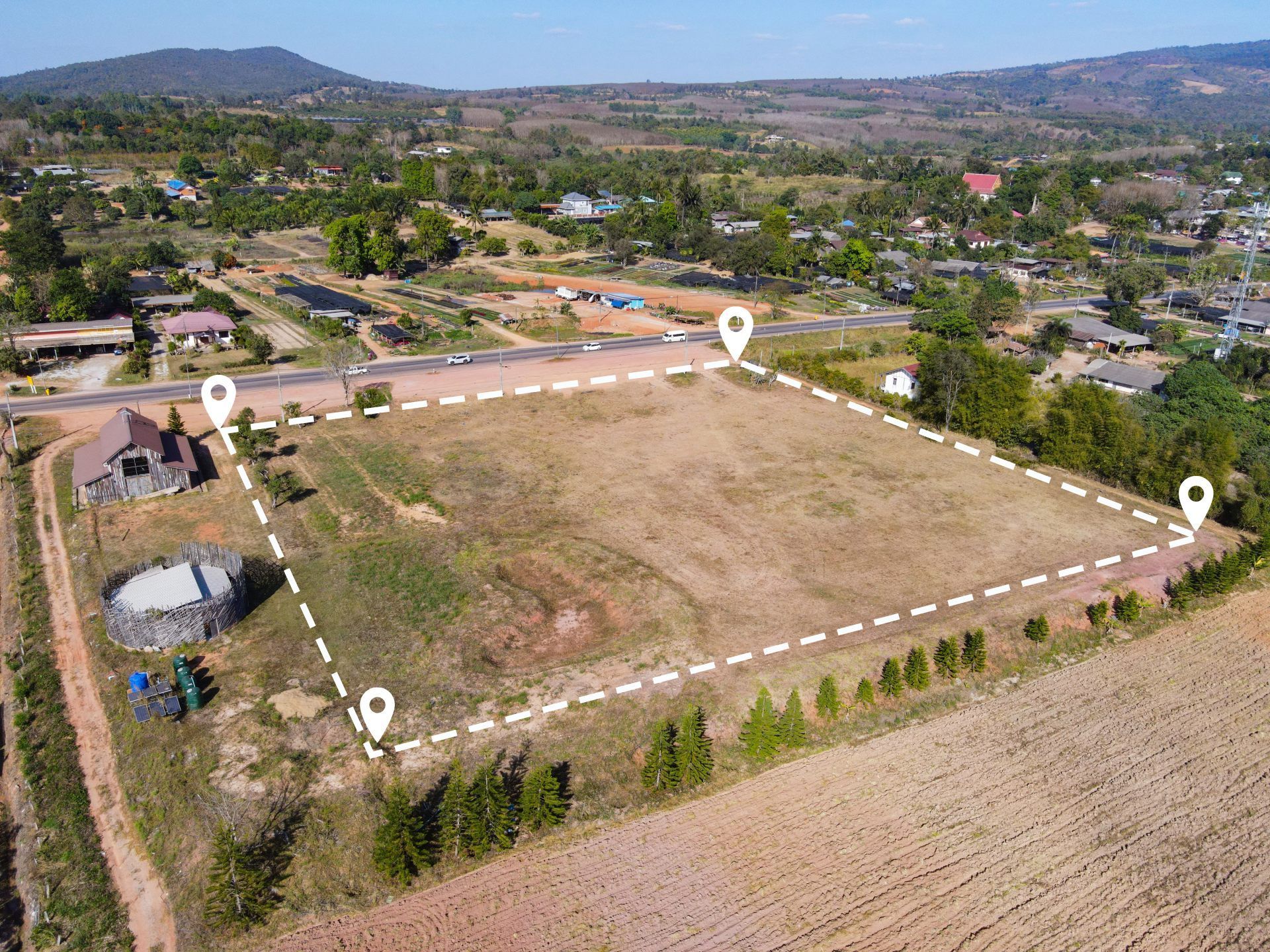
ARO Aerial provides design-grade drone mapping, photogrammetry, and 3D modeling services for architecture, engineering, and design-build firms across Columbus and Central Ohio. We capture and process georeferenced spatial data — orthomosaic maps, digital elevation models, volumetric calculations, and photogrammetric 3D reconstructions — that architects and engineers need to design with confidence. From pre-design existing conditions surveys to as-built verification, our mapping deliverables integrate directly into your BIM, CAD, and GIS workflows.
We serve architects, civil engineers, structural engineers, MEP consultants, landscape architects, environmental engineers, and design-build teams who need accurate, repeatable spatial data to inform site analysis, validate design against field conditions, coordinate across disciplines, and document project outcomes.
FAA Part 107
MBE Certified
EDGE Certified
OSHA 10 Trained
L1 Thermographer
When AEC Teams Need Drone Mapping
- Capture accurate existing conditions data before design begins
- Generate BIM-ready site models and terrain surfaces for design teams
- Compare as-designed vs. as-built conditions with georeferenced overlays
- Measure site topography, grades, and elevation without traditional survey delays
- Support design coordination across civil, structural, architectural, and MEP disciplines
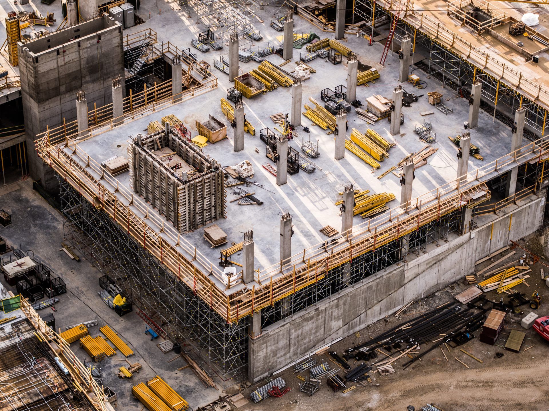
- Validate construction progress against design intent during CA phase
- Produce volumetric calculations for grading design and earthwork estimation
- Create as-built documentation for project closeout, owner turnover, and regulatory compliance
This is not consumer-grade mapping — it's design-grade spatial data built for architects, engineers, and multidisciplinary design teams who need BIM-integrated, survey-quality deliverables.
Deliverables (orthomosaics, DEMs, 3D models, exports)
1. Existing Conditions Site Models
- Georeferenced 3D models of current site conditions
- Terrain surfaces, vegetation coverage, and structure locations
- Elevation data for civil and landscape design
- Baseline documentation for design reference
- Compatible with Revit, Civil 3D, SketchUp, and Rhino
2. Orthomosaic Maps & Design Overlays
- High-resolution, GCP-aligned site maps
- Design overlay comparison — CAD/BIM plans georeferenced onto aerial imagery
- As-designed vs. as-built visual analysis
- Layered exports: GeoTIFF, PDF, DWG
- Integration with BIM coordination and design review platforms
3. Digital Elevation Models for Design
- Digital Surface Models (DSM) and Digital Terrain Models (DTM)
- Contour generation at project-specified intervals
- Grading design surface comparison
- Slope, aspect, and drainage analysis for civil and landscape design
- Design surface exports for Civil 3D and grading software
4. Volumetric & Grading Analysis
- Existing grade vs. proposed grade calculations
- Cut/fill estimation for design development and cost modeling
- Material volume projections for site work coordination
- Progress tracking during grading phase of CA
- Exportable data for engineers and estimators
5. As-Built Verification & Closeout Models
- Final site condition 3D models and orthomosaics
- As-built vs. as-designed comparison documentation
- Georeferenced records for owner turnover
- Regulatory compliance and permitting documentation
- Archival models for long-term project records
How Drone Mapping Works for AEC Teams
1. Project Scoping
We coordinate with your project architect, lead engineer, or BIM manager to define:
- Areas of interest and required accuracy standards
- GCP placement strategy and coordinate datum
- Deliverable formats and BIM/CAD integration requirements
- Capture schedule aligned to design milestones (SD, DD, CD, CA)
- Software ecosystem (Revit, Civil 3D, ArcGIS, etc.)
2. Aerial Data Capture
FAA Part 107–certified pilot executes the mission:
- Systematic grid and oblique flight patterns
- GCP-aligned, sensor-calibrated capture
- Multi-sensor deployment (RGB, LiDAR if needed)
- Consistent parameters for time-series comparison
- Safety-first operations with full regulatory compliance
3. Processing & Delivery
You receive design-ready outputs:
- Processed orthomosaics, 3D models, and elevation surfaces
- Design overlay comparisons and volumetric reports
- Data formatted for your BIM, CAD, and GIS platforms
- Cloud-based access for the entire design team
- Deliverables aligned to your project phase and coordination needs
Service Area — Columbus & Central Ohio
We provide AEC drone mapping and 3D modeling for projects in:
- Columbus
- New Albany
- Dublin
- Westerville
- Grove City
- Hilliard
- Delaware
- Marysville
- Lancaster
- Newark
- And all surrounding Central Ohio markets

Use Cases
01
Pre-Design & Site Analysis
- Existing conditions terrain and surface modeling
- Site topography for civil and landscape design
- Environmental and regulatory baseline documentation
- Feasibility analysis and site constraint mapping
- Context modeling for design competitions and proposals
02
Design Development
- Updated site data as conditions evolve during design
- Grading design validation against existing terrain
- Design surface comparison for civil coordination
- Volumetric estimation for cost modeling
- Client presentation models showing design in site context
03
Construction Administration
- As-designed vs. as-built monitoring during construction
- Grading and earthwork verification against design surfaces
- RFI response support with current georeferenced data
- Multi-discipline coordination with shared spatial models
- Progress documentation for design team review
04
Project Completion & Post-Occupancy
- Final as-built 3D models and orthomosaics
- As-built vs. as-designed comparison records
- Owner turnover documentation packages
- Portfolio and case study deliverables
- Archival models for long-term project records
Why AEC Firms Choose ARO Aerial
- 6+ years of professional mapping and modeling experience
- Understands AEC project phases, BIM workflows, and design team coordination
- GCP-aligned, survey-grade accuracy
- Deliverables formatted for Revit, Civil 3D, ArcGIS, and BIM platforms
- FAA Part 107 certified
- Fully insured
- Fast turnaround aligned to design milestones
- Clear communication with architects, engineers, and BIM managers
AEC Drone Mapping & 3D Modeling — Q&A
How do architects and engineers use drone mapping?
Architects and engineers use drone mapping to capture existing site conditions, generate BIM-ready terrain models, validate construction against design intent, coordinate across disciplines with shared spatial data, and document as-built conditions for project closeout.
What is design-grade drone mapping?
Design-grade drone mapping is the systematic capture and processing of georeferenced aerial data — orthomosaics, 3D models, and elevation surfaces — to the accuracy standards required for architectural and engineering design. GCP-aligned capture achieves sub-inch accuracy comparable to traditional survey methods.
Can drone mapping data integrate with BIM software?
Yes. Drone mapping deliverables — point clouds, 3D models, elevation surfaces, and orthomosaics — export in formats compatible with Revit, Civil 3D, Navisworks, ArcGIS, SketchUp, Rhino, and other BIM/CAD/GIS platforms. Data can be used for site modeling, design surface comparison, and multidisciplinary coordination.
When should AEC teams schedule drone mapping?
Key capture points include pre-design (existing conditions), design development (grading and terrain validation), construction administration (as-designed vs. as-built monitoring), and project completion (as-built documentation). Recurring capture during CA provides the highest value for design coordination and verification.
Get Started with ARO Aerial
Need design-grade drone mapping and 3D modeling for your AEC project?
ARO Aerial delivers BIM-ready, survey-grade spatial data across Central Ohio — built for architects, engineers, and design teams.
