Drone Mapping & 3D Modeling
Drone Mapping & 3D Modeling for Architecture & Design in Columbus, Ohio
ARO Aerial Inc | Professional Drone Services for Design Teams
ARO Aerial provides professional drone mapping, photogrammetry, and 3D modeling services for architecture and design firms across Columbus and Central Ohio. We deliver georeferenced orthomosaic maps, digital elevation models, and photogrammetric 3D reconstructions that give design teams accurate spatial data for existing conditions documentation, site analysis, and design integration — from the earliest site visit through project completion.
We work with architects, landscape architects, urban designers, and planning firms — providing engineering-grade spatial data tailored to the design process. Whether you need a terrain model for grading design, a 3D site scan for BIM integration, or an orthomosaic overlay for site analysis, ARO Aerial delivers accurate, repeatable outputs formatted for your design tools and workflow.
FAA Part 107
MBE Certified
EDGE Certified
OSHA 10 Trained
L1 Thermographer
Why Architecture & Design Teams Use Drone Mapping & 3D Modeling
- Capture accurate existing conditions — terrain, structures, vegetation, utilities, access
- Generate georeferenced site maps for design overlay and analysis
- Build 3D site models for massing studies, context modeling, and design review
- Create digital elevation models for grading, drainage, and landscape design
- Integrate point clouds and meshes directly into Revit, SketchUp, Rhino, and AutoCAD
- Document site evolution across design phases — SD, DD, CD, CA
- Provide defensible baseline data for regulatory and permitting submissions
- Support client presentations with accurate, visually rich 3D site models
This is not generic mapping — it's design-grade spatial data built for project architects, landscape architects, and design teams who need precision and integration.
What We Deliver
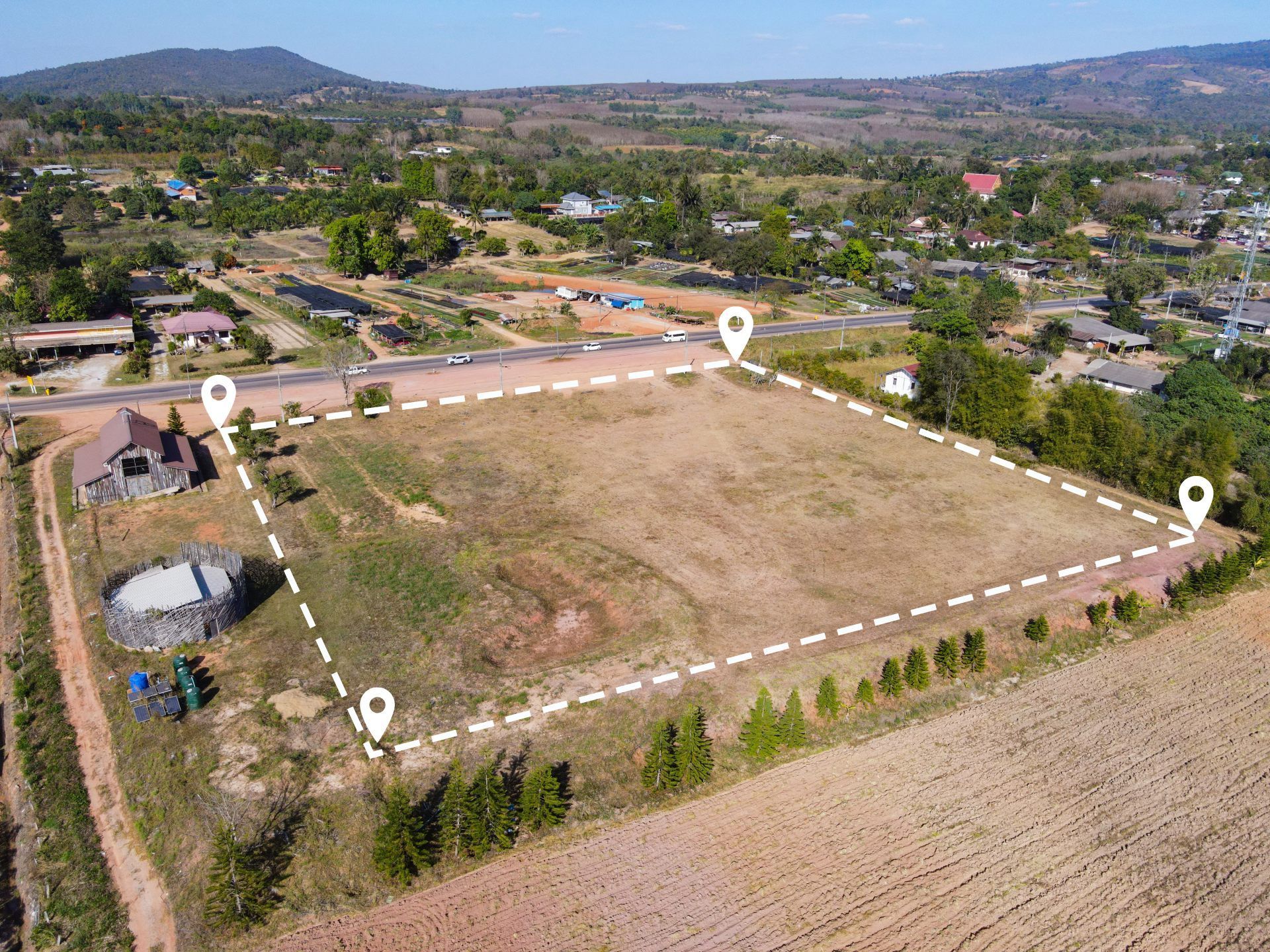
1. Existing Conditions Orthomosaic Maps
- High-resolution, georeferenced site maps for design reference
- GCP-aligned accuracy for reliable overlay with survey and design data
- Documentation of structures, vegetation, paving, utilities, and topography
- Layered exports (GeoTIFF, PDF, JPEG) compatible with CAD and GIS platforms
2. 3D Site Models for Design Integration
- Photogrammetric 3D reconstructions of existing sites and structures
- Mesh and point cloud outputs for Revit, SketchUp, Rhino, and AutoCAD
- Context models for massing studies, shadow analysis, and view studies
- Digital twins of existing conditions for renovation and adaptive reuse projects
3. Digital Elevation Models (DSM/DTM)
- Terrain models for grading design, drainage planning, and landscape architecture
- Contour line generation at custom intervals
- Slope, aspect, and watershed analysis
- Baseline topography for site-responsive design
4. Site Analysis & Context Mapping
- Surrounding context documentation — adjacencies, streetscape, view corridors
- Vegetation, hardscape, and land cover mapping
- Solar orientation and terrain-based analysis data
- Overlay-ready outputs for site plans and design diagrams
5. Design-Phase Progress Mapping
- Recurring capture aligned to design milestones — SD, DD, CD, CA
- Plan-vs-actual overlay comparison during construction administration
- Consistent capture parameters for reliable phase-to-phase analysis
- Timestamped records for project archives and regulatory compliance
How It Works
1. Project Scoping
We coordinate with your project architect or design lead to define:
- Areas of interest and required accuracy (GCP placement)
- Deliverable formats and design platform integration (Revit, SketchUp, Rhino, AutoCAD, GIS)
- Capture schedule aligned to design milestones
- Elevation, terrain, and 3D model requirements
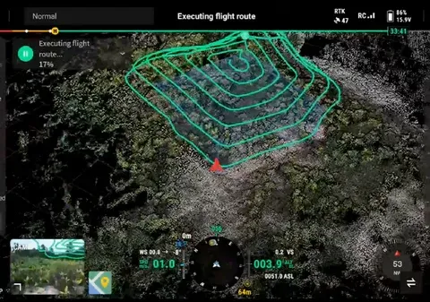
2. Aerial Data Capture
FAA Part 107–certified pilot executes the mission:
- Systematic grid and oblique flight patterns
- GCP-aligned, sensor-calibrated capture
- Multi-altitude imaging for both site-wide and detail-level coverage
- Safety-first operations with regulatory compliance
3. Processing & Delivery
You receive design-ready outputs:
- Processed orthomosaics, 3D models, and elevation surfaces
- Point clouds and meshes formatted for your design tools
- Cloud-based access for your design team
- Integration-ready exports — no additional conversion needed
Service Area — Columbus & Central Ohio
We provide drone mapping and 3D modeling for architecture and design firms with projects in:
- Columbus
- New Albany
- Dublin
- Westerville
- Grove City
- Hilliard
- Delaware
- Marysville
- Lancaster
- Newark
- And all surrounding Central Ohio markets
Architecture & Design Use Cases
01
Site Selection & Feasibility
- Existing conditions mapping of candidate sites
- Terrain and topography analysis for feasibility evaluation
- Context and adjacency documentation
- Visual data for client presentations and feasibility reports
02
Schematic & Design Development
- 3D site models for massing studies and context modeling
- Terrain models for grading and landscape design
- Orthomosaic overlays for site plan development
- View corridor and solar orientation analysis
03
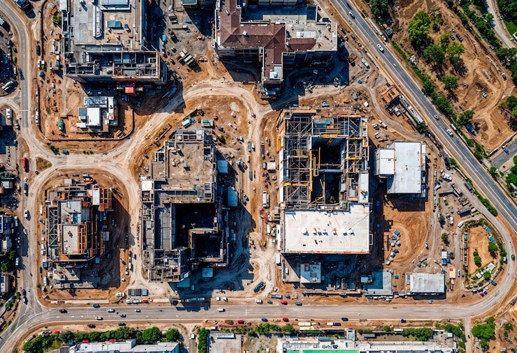
Construction Administration
- Plan-vs-actual comparison during construction
- Design intent verification with georeferenced overlays
- Progress mapping aligned to design milestones
- Visual documentation for punch list and closeout review
04
Renovation & Adaptive Reuse
- Existing building and site documentation for renovation projects
- 3D scans of existing structures for design integration
- Point clouds for as-existing BIM models
- Baseline condition records for historic or adaptive reuse work
Why Design Firms Choose ARO Aerial
- 6+ years of professional mapping and modeling experience
- GCP-aligned, survey-grade accuracy
- Design-platform-ready deliverables — Revit, SketchUp, Rhino, AutoCAD, GIS
- Understands the design process — site selection through CA
- FAA Part 107 certified and fully insured
- Fast turnaround with clear communication
- Trusted by architecture, landscape architecture, and planning firms across Ohio
Frequently Asked Questions (FAQ)
Why Do Architects Need Drone Mapping and 3 D Modeling?
Drone mapping and 3D modeling give architects accurate existing conditions data — terrain models, georeferenced site maps, and 3D reconstructions — that integrate directly into design tools like Revit, SketchUp, and AutoCAD. This supports site analysis, context modeling, and design-phase documentation.
What Design Tools Are Compatible with Drone Mapping Deliverables?
ARO Aerial delivers outputs formatted for Revit, SketchUp, Rhino, AutoCAD, ArcGIS, and other design and GIS platforms. Point clouds, meshes, orthomosaics, and elevation models are exported in industry-standard formats (LAS, OBJ, GeoTIFF, DXF) for direct integration.
When Should Architects Commission Drone Mapping?
The most valuable captures happen before design begins (existing conditions baseline), during design development (site context and terrain data), during construction administration (plan-vs-actual verification), and for renovation/adaptive reuse projects (as-existing documentation).
How Accurate Is Drone Mapping for Architecture Projects?
With ground control points (GCPs) and professional-grade sensors, drone mapping achieves sub-inch horizontal accuracy — providing the precision architects need for site-responsive design, regulatory submissions, and BIM integration.
Get Started with ARO Aerial
Need Accurate Site Mapping and 3 D Modeling for Your Next Design Project?
ARO Aerial delivers design-grade spatial data for architecture and design firms across Central Ohio — formatted for your tools, aligned to your process, and delivered on your timeline.
