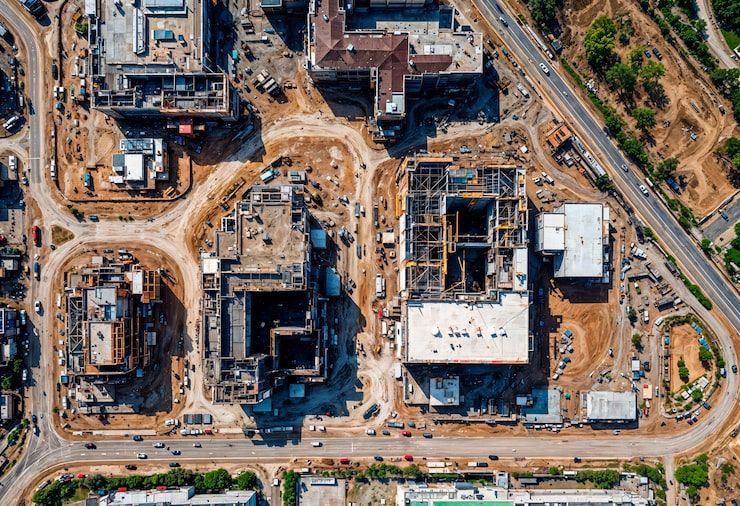
The Most Accurate, Measurable, and Useful Jobsite Documentation in Columbus
ARO Aerial delivers virtual tours built on the iGUIDE® platform, giving construction teams, architects, and developers a powerful way to document, measure, and understand their projects at every stage.
This isn’t a real‑estate tour — it’s a field‑verified digital record engineered for construction workflows.
Why iGUIDE® Is the Superior Choice for Construction Documentation
Most 3D tour systems were built for real estate. iGUIDE was built for accuracy.
ARO Aerial leverages that precision to give Columbus‑area construction teams a competitive advantage.
What makes iGUIDE different?
- Industry‑leading measurement accuracy (±1% or better)
- Fast capture — ideal for active jobsites
- No cloud‑processing delays
- Floor plans + 3D walkthroughs generated from the same dataset
- Measurement tools built directly into the viewer
- CAD‑ready deliverables available
This means your team gets reliable, measurable, defensible documentation — not just a pretty tour.
Built for A/E/C Workflows — Not Just Marketing
ARO Aerial adapts the iGUIDE system specifically for construction, architecture, and development.
Accurate As‑Built Documentation
Capture true site conditions with measurement‑enabled tours and floor plans that support:
- Pre‑construction planning
- Renovation and adaptive reuse
- Layout verification
- Clash detection support
- Design validation
Architects and engineers can verify conditions without stepping on site.
Progress Tracking & Milestone Documentation
Every scan becomes a timestamped record of the project.
Use it to:
- Document rough‑ins before cover
- Track progress for owners
- Reduce rework and miscommunication
- Support pay apps and schedule verification
- Provide visual evidence for disputes or RFIs
Your team gets a transparent, defensible history of the build.
Better Coordination for GCs & Subs
iGUIDE tours make communication frictionless:
- Share a link — no logins or software required
- Annotate issues visually
- Reduce site visits
- Improve coordination between trades
When everyone sees the same thing, decisions get faster.
Facility Management & Turnover
Once the project is complete, the tour becomes a digital operations asset.
Facilities teams can:
- Locate utilities and equipment
- Reference behind‑wall documentation
- Plan future renovations
- Train new staff
This is a long‑term value add that sets Columbus builders apart.
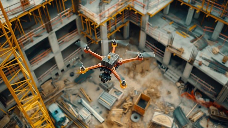
How ARO Aerial Delivers iGUIDE for Construction
1. Capture
We scan the site using iGUIDE’s high‑accuracy camera system — fast, safe, and optimized for active construction environments.
2. Process
You receive:
- A fully navigable 3D walkthrough
- Accurate floor plans
- Measurement‑enabled environments
- Optional CAD/BIM files (DWG, RVT, ESX)
- High‑resolution stills
3. Deliver
Everything is delivered through a secure, shareable link.
No apps. No learning curve. No friction.
Optional Add‑Ons for Technical Teams
- CAD / BIM deliverables
- Point clouds
- Exterior mapping
- Site plans
- Before/after comparison layers
- High‑resolution stills for reporting
Why Columbus Builders Choose ARO Aerial
Local Expertise + Technical Precision
You’re not hiring a photographer — you’re hiring a construction‑focused data partner.
Built for Central Ohio Workflows
We understand the needs of Columbus GCs, architects, and developers — from mixed‑use projects in the Short North to industrial builds in Grove City.
Faster Turnaround
Same‑day or next‑day delivery keeps your project moving.
Premium, Professional, Reliable
ARO Aerial is trusted by teams who need accuracy, not marketing fluff.
Bring Clarity to Every Phase of Construction
ARO Aerial’s iGUIDE‑powered virtual tours give your team the visibility, accuracy, and confidence needed to build smarter — from groundbreaking to handoff.